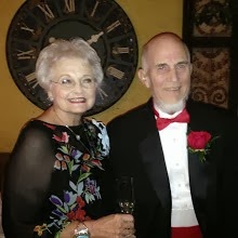
Harrington Travels East 2009
Letter 8: North Carolina
Tuesday April 14, we have to eat some crow about Myrtle Beach. This evening we went to the downtown Myrtle Beach and saw all the beach tourist stuff. Mile after mile of high
Letter 8: North Carolina
Tuesday April 14, we have to eat some crow about Myrtle Beach. This evening we went to the downtown Myrtle Beach and saw all the beach tourist stuff. Mile after mile of high
 rise condo’s, hotels, and beach shops. We could occasionally see the beach. Along Ocean Beach road there were blocks of
  arcades, beach shops and restaurants. This was more what we had pictured for this area. It was still spring break for somebody because there are still kids running around. We have been in spring break since Memphis! North of the downtown section were beautiful homes with the beach as their back yard.
 Wednesday, April 15, Tax day and ours is in! Mailed before we left home. Thanks to Fred!
This town (Myrtle Beach area) is at least 40 miles long—city driving and beach! As we left the area we saw four more volcanoes and speaking of repetition, there are too many to count of: seafood buffets, beachwear stores, arcades, high rise condos or hotels, breakfast/pancake restaurants, miniature golf/golf courses, vacation rentals, and New York license plates. Every gimmick to get your money is represented here. We can see why families want to come here. Lots of activities for kids and adults.
Finally we finished South Carolina. It’s a great state. It took longer than expected. Unlike the earlier reports of poverty and depression for areas around Laurens and Newberry, the coast of South Carolina is alive and well. At least partly from retirees and tourist money.
As we reentered North Carolina there were miles of blooming dogwoods along the freeway. NCDOT has also planted banks of lilies around most of the bridge abutments. They aren’t blooming yet, but they will make an impressive display.
We had a change of tentative plans and rather than following the coast we drove north to Wilson, NC. Why Wilson? It had a Passport America RV park and was the only spot we could find to the east, most important yet near Raleigh. Fred had noticed a cut on the outside of the sidewall of the right rear suburban tire. He had it changed with the spare at Wal-Mart, but they don’t carry Michelin tires. We are a firm believer in Discount Tires and when we looked on line the only and last ones even close to our route were in Raleigh. Since we have their road hazard guarantee , we headed for Wilson.
After parking in Wilson, we drove west and found Discount Tire on the east side of Raleigh. Sure enough they put on a new tire at no charge. We did pay for the road hazard of $30 for the new tire. It was well worth the trip. When asked about going out of the Discount Tire area, they said if we had a problem and had to buy a new tire, to save the receipt and bring it to another DT store and they would reimburse us. You can’t beat that. With 80 pounds of pressure in our rear tires, it could have been quite a blowout if not detected. Fred slept better this night.
To those of you that do not know about Passport America - PA has located RV parks willing to give discounts of 50 percent off their nightly fee to members. It cost us $50 a year to belong. Last year we looked at this, but they didn’t have as many parks where we were going, but this year we looked and it appeared to be a good deal, due to the density of cities and possibilities of needing to stay close to them. Sure enough we have stayed in enough of their parks to more than pay the membership. The one in Myrtle Beach was also PA and was a luxury park, and the two state parks were full. This one was ok, nothing special, but for one night it was fine. We still prefer State, National, County and the free forest camps and will stay there as our first choice any day.
Thursday, April 16, as we were hooking up a couple came over and asked if we were following them or visa versa. We had been in Hunting Island, Charleston (Lake Aire) and the current place together. We chatted and exchanged addresses. They invited us to visit with them near Ottawa. We wished we had met them at one of the other camp grounds. Very nice couple.
We headed east with a strong north cross wind, at one stop, an especially large
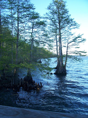
 dogwood caught our eye. We made our way to Pettigrew State Park on the peninsula headed to Nags Head. It is a small campground (13 spots) on the north side of Phelps Lake. The state owns most of the frontage of this 25 square mile lake. It is the second largest natural lake in NC.
 It is a “swamp” lake. Never more than 9’ deep, with a lake bottom containing up to 13’ of peat deposit. Its waters are naturally pure—there is no runoff from streams, just from rain springs. With the peat (very acetic) and other decaying vegetation harmful bacteria don’t exist.
We backed into a
 spot surrounded by large trees (mostly cypress, along with bay and sycamore and other hardwood) and lots of underbrush. It is somewhat protected from the wind, but Fred was afraid of falling limbs from the old tall trees—some 125 feet tall. Sure enough, while visiting with a park ranger, who had come to welcome us, we were all three were startled by a loud noise from the trailer top six feet away. A middle sized limb (3/4 inch diameter and 3 feet long) from high in the trees had landed on top of the trailer. No damage was done, but it was a very loud noise.
The country around this area is very flat with canals dug to drain the swamp for the farm land. In fact, we later learned, this entire area was a swamp until the settlers arrived. We learned about the creativeness of the owner of the plantation Somerset Place. He had the vision to see how fertile the land was and had a canal dug, by his slaves, from his home on the lake to the Scuppernong River about 6 miles away.
We saw many canals all over this very flat land. Along the main canal he planted a row of
 Cypress trees that are now tall and majestic
We are in the midst of the Albermarle-Pamlico Region. This area surrounds the Albermarle and Pamlico sounds (as well as other lesser sounds) for which it is named. It encompasses the 2,000,000 acre estuary located in both NC and Virginia. This is the largest lagoonal estuary system in the USA. It is an ideal nursery for many ocean fish and as such is protected in extensive ways.
One ranger told us there is a lot of wild life in the area. Lately, he has seen bear, turkey, and deer. .
They dug the canal to drain the swap so they could farm the land. They look like irrigation canals, but are actually drainage channels. Even in the field every so often there are small 2-3 foot wide canals for drainage. One road runs along a 30 foot wide canal—it is named 30 foot canal road. Even the borrow ditches from road building are filled with water. There is plenty of water here.
From there they cut cross canals all to drain the swamp and eventually clear the land for crops. They grow strawberries, potatoes, cucumbers, soy beans, wheat and some cotton.
After supper we took off around the lake and stopped at
 a viewpoint, then on around to the south side of the lake and sure enough we saw 2 deer and FOUR black bear. The picture shows the
  back end of one of the bears as he followed his friends into the woods. The bears wouldn’t pose! We saw the sunset behind the cyrpress trees on the banks of the lake.
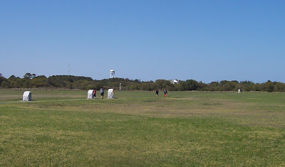
 Friday, April 1, we drove to the Outer Banks of North Carolina. Look on a map and see they are a series of long skinny islands that protrude out into the Atlantic and serve as barrier islands to the main land. We turned south on the island and checked out a National campground at Oregon Inlet. It was sufficient with no hookups and probably in the summer would be a good place to stay, but for now we were glad we were inland. At one of LaGail's recommendations we drove on further south to Chicamacomico
  (pronounced Chik-a-ma-COM-i-co) Life-Saving Station. The history of life-saving began in 1784. These tiny refuges dotted the Massachusetts coastline south to South Carolina. In 1871 the US Life-Saving service was restructured and it’s sole purpose was “To rescue those in peril from the sea.” In 1915 it became the US Coast Guard. Chicamacomico was decommissioned in 1954 and is now under a 501c3 Historical Association. We were fascinated by a map showing the outer banks as the
  Graveyard of the Outer Banks with over 600 known and identified shipwrecks. Thanks LaGail for this and other recommendations.
We watched the waves
 on the beach and
  thought of Daniel who loves to surf.
Heading north we drove through Kill Devil Hills (a town), between Kitty Hawk and Nags Head, to the Wright Brothers National Memorial. They had been welcomed to the resort community of Kill Devil Hills to try their experiments.
In the visitors center and 1st in Flight hall of fame we were pleased to see
 Bessie Coleman’s picture, a native of Waxahachie and the first African American woman pilot ever. Go Waxahachie! Go Bessie! Fred wonders why don’t we do more to honor her In Waxahachie?
The Wrights learned to fly on a stretch of beach near the Kill Devil Hills. It provided isolation, high dunes, strong winds and soft landings.
We saw their monument on top of a
 Kill Devil Hill, where they tested their
  glider, along with their workshop and hanger.
After several years they were successful on their
 fourth motorized flight of 59 seconds and 852’. The markers are for each of the four flights. We drove around the Monument and Fred
  joined Orville for another flight.
Saturday, April 18 we went sight seeing again, this time on Roanoke Island—just inside of the barrier islands. We first went to the south end to the community of Wanchese, pronounced “Won-cheese” after one of the Indian braves who befriended the “lost colony” English settlement in 1585. This is the center of fishing industry of the area. It is near the Oregon Inlet of the outer banks, so it is protected but accessible to the Atlantic.
Then north to the Roanoke Festival Park where we saw a movie “The Legend of Two Path” about the Indians and the first settlers. There was also the Roanoke Adventure Museum and a settlement where Fred tried his hand at
 shaving a piece of wood.
Then we ventured out on the
 Elizabeth II sailing ship which brought the 1585 settlers to Roanoke Island from England. The crew was
  setting the rigging and
 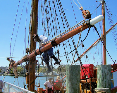 we enjoyed watching.
  Fred enjoyed talking to the crew and
  hoisting the anchor. The crew was dressed in period costume and answered questions as if they were from the earlier time. They were very good and informative. The entire exhibit is done to a very high standard. Well done!
To complete Roanoke Island we visited Fort Raleigh and the
 earthen fortification. They also have an outdoor play in the summer about the “Lost Colony” in their
  water-view park. We would have enjoyed seeing the play. It was nice to be back in the state park for a peaceful evening and some rest. This had been two hard days.
Sunday, April 19, we attended the
 Mt Herman UMC near Cherry, NC. Their pastor was absent and a 16 year old, junior in High School presented the sermon. They were very proud of one of their own young people. On our way back to Pettigrew State Park we drove past the
  Davenport farm, home of Washington County’s first senator in 1800.
On the other end of the spectrum we walked down a carriage road past our trailer to Somerset Place. During its eighty-year existence as an active plantation (1786-1865), Somerset Place encompassed as many as 100,000 acres and became one of NC most prosperous plantations. Cumulatively, it was home to more that 800 enslaved men, women and children. Many of the enslaved dug a system of irrigation and transportation canals; a sawmill, gristmills and barns.
 The building on the far left is a slave house, then a 4 family slave house, the school and the family home.
The family home faces the canal and the side of the lake. There was also a hospital,  school, overseers house, dairy, kitchen, laundry,
  gardens, smokehouse and salting house. The guided tour was free and lasted about 1.5 hours. She told us of two of the enslave families have had huge reunions at the plantation along with the Collins family who owned the place. The guide was very educated about the plantation, owners, slaves and even the construction of the buildings. Many slave descendants continue to live in the area and provided a wealth of information for this project.
Monday, April 20 we said goodbye to North Carolina as we stopped at the Dismal Swamp Canal. This was also built with slave labor before the revolution with George Washington as a part owner in this land development venture.. Now it is an scenic route for the Inter-coastal canal. It runs from Virginia into North Carolina.
school, overseers house, dairy, kitchen, laundry, gardens, smokehouse and salting house. The guided tour was free and lasted about 1.5 hours. She told us of two of the enslave families have had huge reunions at the plantation along with the Collins family who owned the place. The guide was very educated about the plantation, owners, slaves and even the construction of the buildings. Many slave descendants continue to live in the area and provided a wealth of information for this project.Monday, April 20 we said goodbye to North Carolina as we stopped at the
Dismal Swamp Canal. This was also built with slave labor before the revolution with George Washington as a part owner in this land development venture.. Now it is an scenic route for the Inter-coastal canal. It runs from Virginia into North Carolina.Love to all, and we enjoy hearing your comments,
email: olivia@bobheck.com or fredharrington@yahoo.com
PS: Jean Paul, we do not have your email correct, please email us.